
Apr 20 2013
Waze in WA
A few months ago I was recommended to download a free app called Waze. I took me a while to get round to it but I was intrigued to find out that this was a crowd sourced GPS application with live traffic reporting. How did Waze perform in Perth? Apple Maps had issues in Western Australia, would this app be a fair replacement.
My interest quickly waned when I started the app on my phone and keyed in my address and Waze couldn’t find my house. Not to be deterred I scrolled around the map and found my street was there, but that it hadn’t been named. Whilst my neighbourhood is reasonably new to the city it isn’t that new. I was tempted to delete the app but thought I would at least try it on my drive into the city the next morning.
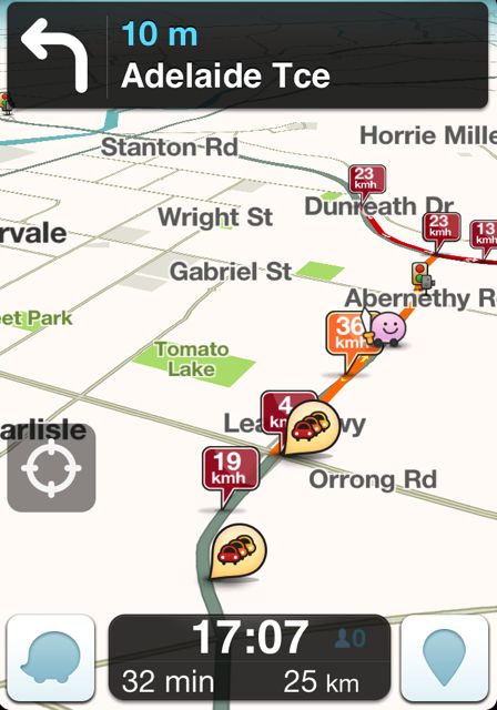 Now things started to look better. Waze has one key feature, it crowd sources traffic data from users and will display this on the map screen in a clearly graded manner. It also allows users to alert other drivers to where traffic jams start, obstacles on the road, speed cameras and the like. I was hooked. The traffic reporting is of course dependent on the amount of Wazers using the app and driving around. Perth seems to have a good number of drivers out there so there is some good accurate traffic info, especially on the freeways.
Using Waze as a straight forward GPS does have some limitations in Perth at the moment as not all streets and suburbs are mapped. The search options allows you to use Waze results, Google or FourSquare. Where the app gets really useful is that it learns your destinations for different times and days, so by the time I’m off the driveway Waze has asked; “Are you going to work?”. If you don’t prompt the app any further it assumes a yes answer and routes you to work.
Waze also learns an stores road speed data, in what appears to be 15 minute time slots. So this means the servers can calculate the fastest route for you based on historical data. I have actually seen my driving using the app change the route Waze recommends I take home. Most GPS units and apps will use average road speeds to determine a route. They will also tend to try and get you to the nearest freeway and then take this to the nearest junction to your destination. My Garmin GPS always recommends I drive past my suburb on the freeway and then double back to my house. Waze started by doing this too. However I ignored Waze day after day and came off at my preferred junction, before long Waze had used the speed data from my driving and was now recommending my quicker route. This has also worked the other way round where Waze has shown me a quicker way through the CBD in the morning rush-hour.
Lastly and by far the most useful feature in Waze is the fact that the map is editable. Log onto the waze website at http://world.waze.com and you are able to edit the map. A few days later your changes will be live on the app. Think about how long this takes with some of the major GPS players in the market. So whilst Waze might have a few holes in the map here and there, you can go and fill them in. Changes in road layout, such as those in Perth around the Elizabeth Quay development, can be remapped and available within days meaning that in many ways this is more accurate.
Waze is available on the Apple App Store and Google Play Store.
![]()
This post written by Adrian Lindley – find me on Google+